Guest blog post by Maeve Hitchcock
“Throughout New England, there are more than 400 small villages and towns whose evolution and development have been tied to the presence of a mill” (Dunwell, 1978). Ipswich, and many of the other towns within the Ipswich River Watershed, are no exception to this history.
Here at the watershed we talk a lot about mills and dams but where (and what) exactly are they? What were they used for, and what kind of impacts do they have on the river and surrounding environments today?
Simply put, mills are buildings which are equipped with the machinery to carry out a particular manufacturing process. What mills create, and what they look like, vary widely depending on the specific purpose and location. Common types of mills that could be found across New England include paper mills, textile mills, saw mills, and grist mills (mills used to grind grains into flour).
Dams are barriers “constructed to hold back water and raise its level, forming a reservoir used to generate electricity or as a water supply” (Oxford Advanced English Dictionary, 2025); in the context of mills, dams were erected to serve as an energy source. Water being held up by the dam could be channeled over a simple turbine called a waterwheel which then spins rapidly as the water runs over it and converts “the kinetic energy of water into mechanical movement” (Waterwheel Work: Energy Transformations and Rotational Rates – Activity, 2023).
While they were once an important part of the local economy and culture, many of these structures no longer serve any functional purpose and actually present hazards to both the environment and potentially to people in the event that they collapse.
We advocate for dam removal because dams negatively impact local ecosystems in several key ways (Massachusetts Rivers Alliance, n.d.):
1. Dams prevent fish migration:
Migratory fish species rely on unobstructed access to the river in order to migrate and spawn in their historical spawning grounds. Even when dams have fish passages, many species will often still struggle to pass through successfully depending on the specific design and conditions of the passageway.
2. Dams alter aquatic habitat:
The presence of a dam can impact how sediment and organic matter which serve as important sources of food and habitat flow and are deposited in the surrounding environment.
3. Dams alter river flow:
Unnatural variations in the depth and or flow rates of the water caused by the dam impact both habitats formed in the riverbed and the behavior of different species.
4. Dams significantly alter water quality and temperature
Changes in water flow can impact water temperature, which in turn alters the amount of dissolved oxygen (an important indicator of river health) present in the water. Warmer water typically holds onto less dissolved oxygen than colder water, and a lack of oxygen can be detrimental for the health of many different species.
There are currently 3 dams along the main stem of the Ipswich River, but hundreds more are dotted across the river’s many tributaries. Because understanding these obstructions is so important, extensive surveying and modeling has been conducted by a wide variety of organizations and entities in the region. The Massachusetts Division of Ecological Restoration has many resources where you can find out more information about dams, the current condition of any given dam in the state, and updates on different removal projects that they are working on.

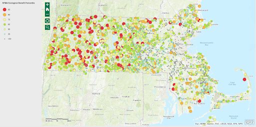
Map from Massachusetts DER, Dam Removal and Ecological Benefit Estimation Tool, 2025
This map from the Massachusetts DER Dam Removal and Ecological Benefit Estimation Tool highlights the shocking number of dams present throughout Massachusetts! Dams which present the greatest potential for ecological benefit upon their removal are modeled in red. A closer look at the Ipswich River Watershed region shows that the Ipswich Mills Dam is rated in the 95th percentile of all dams and that its removal will eventually connect nearly 50 miles of river! (Massachusetts Division of Ecological Restoration, n.d.)
IRWA also conducted its own barriers assessment in 2018 which assessed 1,026 potential barriers across 280 square miles in the Parker, Ipswich and Essex river watersheds (https://pie-rivers.org/documents/GM_BarriersAssessment_FullReport_IRWA2018.pdf). Assessments like these are important because they help organizations like IRWA, and other partner organizations in the area plan project priorities in collaboration with one another so we can build a more resilient watershed.
Furthermore, historical documentation, such as that provided by the Massachusetts Historical Commission’s Cultural Resource Information System (MACRIS), can provide detailed records on specific sites. I explored this information to learn more about one site we visited recently, the Old Farnum Mill Dam in North Andover: The mill was originally constructed around 1750 for use as a sawmill and has been repaired several times as the building conditions degraded over the years. After the installation of a diesel engine in the 1960’s, the mill no longer relied on water power, though the water power was utilized on occasion throughout the year to prevent the seizure of related machinery. The mill remained in functional condition through at least 1975, though today it is in a state of disrepair – not unlike many of the other mills throughout the region.
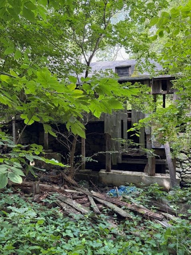
The Old Farnum Mill and adjacent mill pond, July 2025
Dams are a common type of obstruction that you may encounter in the region, though they are not the only type of barrier that present a potential issue for river health and wildlife. Culverts, a human made tunnel with openings on either end, are often used to connect two bodies of water and are installed at many different points along the Ipswich River and its tributaries. Culverts often run underneath infrastructure such as highways, roads, and bridges. When properly designed and installed, culverts can be beneficial as they allow water to flow freely and provide a safe transportation system for wildlife. When culverts are undersized or otherwise improperly constructed they can become choked up with vegetation, limit the flow of water, and obstruct passageway for animals – often forcing terrestrial and semiaquatic animals like turtles to make a dangerous crossing on the road if they are unable to pass through the culvert easily. Improving culvert infrastructure in the watershed is another top priority here at IRWA!
Removing dams and upgrading culverts in our local waterways are important steps towards building a more climate resilient future.
In the context of climate change, mitigation can be thought of as actions which involve “reducing the flow of heat-trapping greenhouse gases into the atmosphere, either by reducing sources of these gases (for example, the burning of fossil fuels for electricity, heat, or transport) or enhancing the “sinks” that accumulate and store these gases (such as the oceans, forests, and soil)” (Mitigation and Adaptation, 2024). On the other hand, adaptation ”involves adjusting to actual or expected future climate” where the goal is to reduce our risks from the harmful effects of climate change” that we already know are coming (Mitigation and Adaptation, 2024).
Both types of projects are important, and in conversations around climate change there is often considerable debate as to how resources should be dedicated to mitigation or adaptation focused projects as they deal with climate change from slightly different perspectives.
Regardless, both migration and adaptation projects are essential parts of a more resilient future, and dam removal is one powerful way we can work towards this goal!
References
Massachusetts Division of Ecological Restoration. (n.d.). Dam Removal and Ecological Benefit Estimation Tool. https://mass-eoeea.maps.arcgis.com/apps/MapTools/index.html?appid=f573dc437265480f87e31f413e527a3c
Massachusetts Rivers Alliance. (n.d.). Dams and Hydropower. Massachusetts Rivers Alliance. Retrieved July 29, 2025, from https://www.massriversalliance.org/hydropower-and-dams
Mitigation and Adaptation. (2024, December 4). NASA Science. Retrieved July 18, 2025, from https://science.nasa.gov/climate-change/adaptation-mitigation/
Waterwheel Work: Energy Transformations and Rotational Rates – Activity. (2023, October 5). Teach Engineering. Retrieved July 18, 2025, from https://www.teachengineering.org/activities/view/cub_energy2_lesson08_activity2