Back in 2022, we wrote a blog where we highlighted the importance of riverfront delineation in the watershed. Two years later, we are still dealing with many of the same issues. Pressure to permit and build new developments close to the river has only increased and we are still stuck with a set of regulations that lacks clear guidance on how to identify Riverfront Areas on low-gradient, wetland-dominated waterways like the Ipswich River and many of its tributaries.
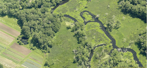
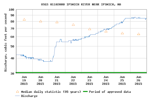
To give an example of what we mean, in the picture below is a stretch of the Ipswich River with a high resolution aerial photo taken on June 22nd 2015. According to the USGS stream gage just downstream of this location, the river was flowing at around 60 cubic feet per second (cfs), which is normal for this time of year.
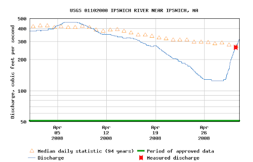
Now, here is a photo of the same stretch of river on the Topsfield/Ipswich boarder, taken on April 9th, 2008. The river was flowing at around 400 cfs, which is normal for this time of year:
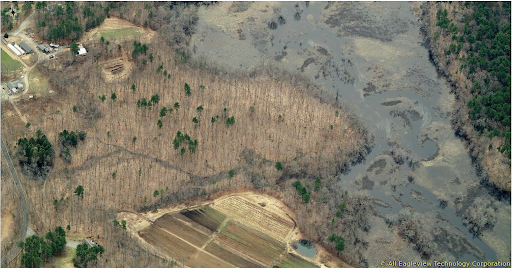
You don’t have to be a fluvial geomorphologist to see the difference! The Ipswich River regularly flows outside of its banks, even during non-flooding times. This is important because what the Riverfront Area is based on is the river’s Mean Annual High Water (MAHW) line. This line is supposed to mark the transition from land that regularly sees river action to “upland” that more rarely sees river action (i.e. during significant floods).
The Riverfront Area by rule is a protected resource area that extends 200 feet from the MAHW line. So you can see how different this area would be if you drew a line starting from the edge of the clear channel in the June 2015 photo versus drawing that line starting from the edge of inundation in the 2008 photo. The caveat to all this is that this delineation needs to be confirmed in the field; one should be able to go out during June/July and be able to see clear indicators of where the river was during March/April.
This is why it is so important to carefully review and scrutinize projects that are near the river. We are actively dealing with a few Riverfront delineation discrepancies, including in Boxford and Wilmington. Not everyone is familiar with how the Ipswich River works – that is why we here at IRWA will always provide our professional opinions to local Conservation Commissions. We need to make sure that these critical Riverfront Areas are properly identified and protected!