Salt marsh once covered over 32 million acres of the globe’s surface, which is roughly equivalent to the area of the state of Louisiana. Today, there are just over 13 million acres left — over half of the global salt marsh has been lost.
The North Shore is home to the Great Marsh, which extends from western Gloucester to southern New Hampshire. The Great Marsh consists of 10,000 acres of salt marsh, making it the largest continuous salt marsh system north of Long Island.
The Great Marsh is an incredible natural resource and habitat, and has many ecological functions and benefits — one of which is acting as our first line of defense against coastal flooding. The Great Marsh acts as a giant sponge that reduces flooding by slowing and absorbing water, both freshwater flooding from precipitation and coastal flooding from storm surge. Our coastal communities in the North Shore and their shorelines are protected from erosion by the Great Marsh buffering wave action and absorbing storm surges and high tides. The Great Marsh is essential for healthy fisheries, coastlines, and communities, and while they are an integral part of our economy and culture, salt marshes are struggling to keep pace with sea level rise from climate change.
The Great Marsh has experienced more frequent flooding in the past 50 years than ever before. In many cases, the flooding has been made worse by outdated and inadequate infrastructure — the main culprit being undersized culverts. Undersized culverts restrict tidal flow and natural tidal processes, and roadways fragment marsh habitat and disrupt continuity of the marsh, all of which harms the ability of the marsh to function.
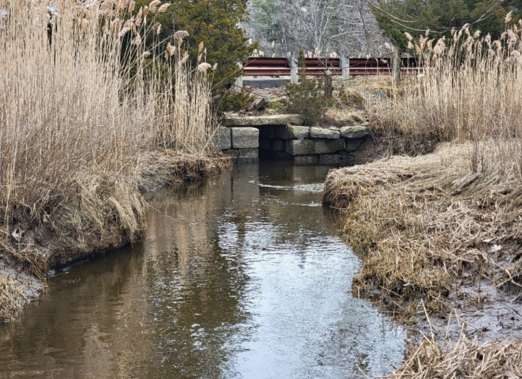
Recently, we have been working in a tidal creek at the border of Ipswich and Essex known as Castle Neck River that connects to the Essex Bay system. It runs under Old Essex Road, passing through an old stone culvert that is undersized and restricts tidal flow. Old Essex Road bisects a portion of the Great Marsh, fragmenting the marsh habitat. The combination of undersized culvert and fragmented habitat causes an array of impacts, including pooling, erosion, delayed tidal flux, impaired marsh health, and overall limited stream and habitat connectivity.
Our project will “daylight” Castle Neck River by removing just over 14,000 square feet of roadway and roadbed that is currently fragmenting the marsh as well as an undersized culvert that acts as a major tidal restriction. This project will restore tidal exchange, improve water quality, and reconnect marsh habitat. Stream daylighting — the process of uncovering streams that were previously enclosed by underground pipes, concrete channels, or culverts — is an important process that mitigates floods and restores habitat. Road abandonment is a form of managed retreat, which is the purposeful movement of people and infrastructure away from risks. By combining daylighting with managed retreat, this project will restore the natural coastal habitat to act as a buffer against flooding and allow the shoreline to move inland. These are important tools to use in climate change adaptation and marsh restoration.
To read more about the project process, please visit https://www.ipswichriver.org/castle-neck-river/ and check out the PDFs linked here to read our resulting report from our recent pre-restoration monitoring efforts.
Looking forward to the day Old Essex Road bridge is no more. I think many of us have had our sites on this project for over 20 years now. Thank you IRWA for seeing this project through. Hopefully some more dsm removals will move forward soon as well!
This is very interesting. The marshes are so beautiful and so important. Thank you for your work to save and improve the marshes.